

As spring fades, Korean peninsula braces for record summer heat
May 21, 2026, 09:22 am


 |
The Korean Peninsula is expected to endure another period of severe hardship this summer due to projected extreme heatwaves. Unprecedented heat has arrived well ahead of schedule, with temperatures in May already soaring past 30 degrees Celsius and triggering an early surge in heat-related illnesses. Following last year’s record-breaking summer—which rewrote charts for the highest average temperatures ever recorded—dominating forecasts indicate that this summer will be even hotter than usual. Furthermore, rainfall is highly likely to manifest as sudden, torrential downpours rather than steady precipitation. Driven by the accelerating climate crisis, extreme weather is fast becoming the new normal.
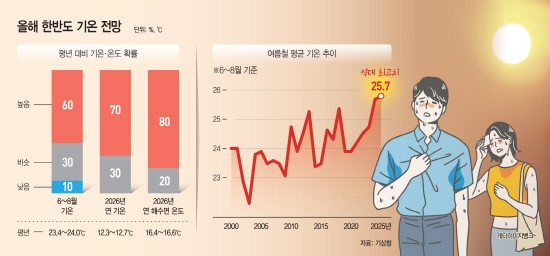
According to the Korea Meteorological Administration (KMA), there is a 60% probability that average temperatures from June to August will surpass the historical norm of 23.4 to 24.0 degrees Celsius. The likelihood of temperatures remaining near average stands at 30%, while the chance of cooler conditions is pinned at a mere 10%. A ridge of high pressure hovering over the peninsula has effectively blocked cooler air from drifting down from the north. Consequently, intense summer heat is poised to strike as early as June, a month traditionally considered early summer. The probability that nationwide temperatures will remain near or above average through the end of June sits at 90%.
The reality of consecutive summers growing increasingly hotter is no longer a novelty. Average summer temperatures in South Korea have climbed steadily, rising from 23.9 degrees Celsius in 2020 to 25.6 degrees in 2024 and reaching 25.7 degrees in 2025, repeatedly setting new highs. Experts attribute this rapid warming primarily to rising sea surface temperatures accelerated by the climate crisis. Warmer seas fortify and prolong the North Pacific High, the atmospheric system responsible for Korea's stifling summer weather. When this system overlaps with an expanding Tibetan High, it creates a "double blanket" effect over the peninsula, causing frequent stretches of extreme heat like those witnessed last year. The KMA projected a 0% probability that either sea surface temperatures or annual average temperatures this year will fall below historical norms, meaning there is zero guarantee this summer will be any more bearable than last year's record-breaker.
Making matters worse, the heat has manifested significantly earlier this year. While last year saw daytime highs hovering around 40 degrees starting in June, this year has already logged consecutive days of 30-degree weather in May. In Seoul, temperatures topped 30 degrees on May 14, hitting a high of 31.4 degrees—reaching that threshold a full week earlier than last year. This premature scorching weather has led to a spike in heat-related illnesses. Data from the Korea Disease Control and Prevention Agency (KDCA) revealed that 69 cases of heat-related illnesses were reported nationwide between May 15 and 18. This marks a more than fourfold increase compared to the 15 cases recorded during the same period last year. Tragically, the extreme weather has already turned fatal, with an 80-year-old man dying from a heat-related illness in Dongdaemun District, Seoul, on May 16.
This trend of earlier and more intense heatwaves is part of a well-documented shift. Over the last 30 years (1996–2025), Seoul recorded 35 days in May where temperatures reached 30 degrees or higher, a nearly threefold jump from the 12 days logged during the preceding 30-year period (1966–1995). This has fueled growing concerns that spring is effectively vanishing from the Korean Peninsula.
The heat is expected to intensify from June onward as migratory high-pressure systems move across an already warmed peninsula. These systems bring clear skies that cause daytime temperatures to spike sharply. By July and August, the North Pacific High will blanket the region, trapping thermal energy and ushering in peak midsummer humidity. The KMA noted that sea surface temperature patterns in the North Atlantic are strengthening anticyclonic circulation in Korea's upper atmosphere, which, combined with increased solar radiation and adiabatic warming, will likely drive temperatures up. The agency added that elevated sea surface temperatures in the northern Indian Ocean are also expected to push temperatures above average starting in July.
Because the pace of global warming on the Korean Peninsula outstrips the global average, the tangible impacts of climate change are becoming starkly visible. Temperature surges that used to be measured across decades or centuries are now unfolding over much shorter intervals. According to the "Korean Climate Change Assessment Report" published jointly by the KMA and the Ministry of Environment last year, South Korea's average temperature rose by 1.7 degrees Celsius over a 100-year period (1906–2005)—more than double the global average increase of 0.75 degrees. The National Institute of Meteorological Sciences warned that if warming progresses beyond 2 degrees, humanity will enter an unprecedented and perilous environment.
Precipitation patterns this summer are expected to mirror last year’s sudden, localized downpours. Although the probability of total summer rainfall exceeding average levels is relatively low at 20%, the repetitive nature of short-duration, localized storms means the scale of potential damage could be severe. The KMA projected that well-developed low-pressure systems and atmospheric instability will trigger periods of heavy, concentrated rainfall.
In anticipation of this extreme summer, the KMA has overhauled its weather warning systems. This year, the agency introduced a top-tier "Severe Heatwave Warning," upgrading the traditional two-tier system of advisories and warnings. The severe warning will be triggered if a region already under a heatwave warning is expected to experience a maximum daily perceived temperature of 38 degrees Celsius or higher, or a maximum daily temperature of 39 degrees or higher, even for a single day. The KMA also established a "Tropical Night Advisory" to monitor overnight heat. This advisory will be issued in regions under a heatwave advisory or higher if the minimum overnight temperature is projected to remain at or above 25 degrees Celsius for just one night. A KMA official explained that because the region is experiencing extreme weather that consistently surpasses old thresholds, the warning framework was updated to better align with the era of anomalous climate shifts.
Most Read
-
1
Samsung Electro-Mechanics signs 300 billion won ML..

-
2
Pentagon reports roughly 100 U.S. troops injured i..

-
3
Trump says decision on large-scale attack on Iran..

-
4
Xi's loyalists to be at forefront of next leadersh..

-
5
South China on high alert as typhoon Noul expected..

-
6
New UK prime minister holds talks with Zelenskyy

-
7
Taiwanese President Lai Ching-te voices opposition..

PEOPLE


-
Address : In-Young Bldg., 34, Uisadang-daero 1-gil, Yeongdeungpo-gu, Seoul
Copyright by ASIATODAY CO., LTD. All rights resereved