



Record tropical nights expected this year
Aug 25, 2026, 09:29 am


 |
Even though "Cheoseo," the traditional seasonal division marking the easing of heat, has passed, sleepless nights continue. Tropical nights this year are showing a record-breaking schedule. As the North Pacific High that causes heat waves remains positioned over the Korean Peninsula for an extended period due to rising sea surface temperatures and other factors, it is observed that sweltering heat will persist this year at least through early September.
According to the Korea Meteorological Administration on the 24th, tropical night advisories are currently in effect across most areas, except for some regions such as northern Gyeonggi and North Chungcheong. In Seoul, a tropical night returned after nine days as the lowest temperature recorded between 6 p.m. on the 23rd and 9 a.m. on this day reached 25.4 degrees Celsius. The KMA announced that it would issue tropical night advisories for southeastern, northeastern, and northwestern Seoul effective from 6 p.m. that day.
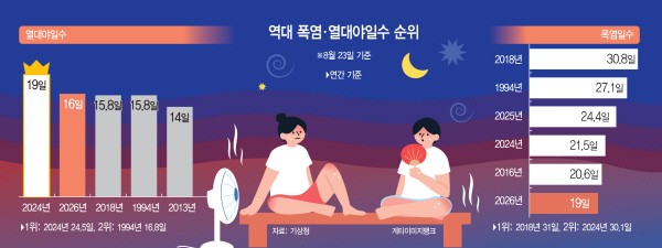
Tropical nights have been particularly frequent this year at record levels. As of the 23rd, the number of tropical night days stood at 16.0 days, ranking second behind 19.0 days during the same period in 2024. Considering that annual tropical night days were highest in 2024 (24.5 days) followed by 1994 (16.8 days), securing the second-highest record in history is deemed certain. Most figures related to sweltering heat this year—including average maximum temperature, average minimum temperature, and average temperature—rank within the top five of all time. Only the number of heatwave days ranks sixth at 19.0 days.
There is a possibility that sweltering heat like the present will continue until the first ten days of September, pushing related records even higher. According to the KMA medium-range forecast, morning lows are projected to stay between 19 and 26 degrees Celsius and daytime highs between 27 and 33 degrees Celsius at least until September 3, remaining higher than average years (lows of 18 to 23 degrees Celsius, highs of 27 to 30 degrees Celsius). Rain across parts of the country this weekend might temporarily lower temperatures, but since the North Pacific High causing heat waves will hold its position over the Korean Peninsula, temperatures are highly likely to rise again once the rain stops.
The KMA explained, "The North Pacific High is beginning to affect our country again, and with the influx of hot and humid southerly air, temperatures are expected to remain high during this period."
Sweltering September heat on the Korean Peninsula is no longer an unusual phenomenon. Previously, there was even the phrase "Cheoseo magic," referring to the idea that heat would begin to break once Cheoseo passed around August 22 or 23. However, over the past decade (2016–2025), heat waves have begun earlier and tropical nights have ended later compared to the past decade (1973–1982), showing a pattern where heat persists for three months across June to September. This is due to the influence of the North Pacific High—which used to weaken around Cheoseo—lingering late as surrounding sea surface temperatures rise.
Over the past three years, the trend of tropical night periods extending later has become even more pronounced. In 2024, when the number of tropical night days was the highest, Seoul recorded its first-ever September heatwave warning alongside the latest tropical night in 89 years. Unlike this year, which saw low precipitation, prolonged heavy rains nationwide last year still saw heat waves and tropical nights observed across the country into early September. This year in particular, with some observations suggesting that precipitation over the Korean Peninsula will decrease in September under the influence of ongoing El Niño, it is projected that heat waves will continue until the North Pacific High completely retreats. However, the KMA stated, "To date, we expect the impact of El Niño on the Korean Peninsula to be limited."
Along with this, daytime temperatures are also increasing the number of heatwave days. Heatwave advisories and heatwave warnings are issued when daily maximum apparent temperatures are expected to reach 33 degrees Celsius or higher and 35 degrees Celsius or higher, respectively, for two or more consecutive days. Effective at 11 a.m. that day, heatwave warnings were issued for southeastern Seoul (Gangnam-gu, Seocho-gu, Songpa-gu, Gangdong-gu) and northeastern Seoul (Seongdong-gu, Gwangjin-gu, Dongdaemun-gu, Jungnang-gu, Seongbuk-gu, Gangbuk-gu, Dobong-gu, Nowon-gu). In Seoul, all heatwave alerts were lifted on the 19th before heatwave advisories were reinstated across the entire area the previous day. Just one day later, some areas in Seoul were upgraded to heatwave warnings, and southern Gyeonggi, the Gangwon east coast, the Chungcheong region, and parts of the Gyeongsang region were also upgraded to heatwave warnings.
Kim Hong-chan
Most Read
-
1
Celltrion nears additional contract with major U.S..

-
2
Putin proposes trilateral U.S.-China-Russia summit..

-
3
U.S. weighs dropping MOAB, world's most powerful n..

-
4
"Aren't those foreigners on welfare?": M..

-
5
Attention centers on APEC for possible Trump-Xi-Pu..

-
6
Saudi Arabia, Iran hold first diplomatic talks to..

-
7
China tightens grip on boosting domestic demand an..

PEOPLE






-
Address : In-Young Bldg., 34, Uisadang-daero 1-gil, Yeongdeungpo-gu, Seoul
Copyright by ASIATODAY CO., LTD. All rights resereved