



S. Korea, UNC disagree on 60% of MDL baseline, fueling risk of clashes over N. Korean mines
Oct 07, 2026, 02:31 pm


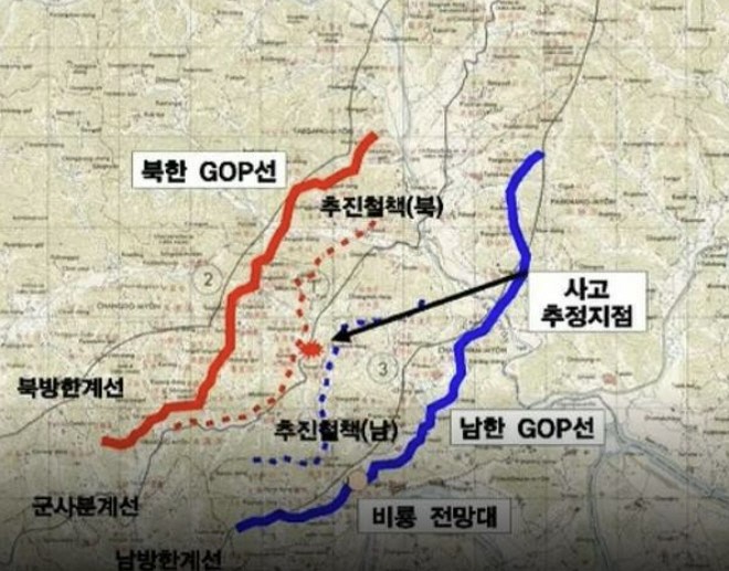 |
| An operational situation map clearly illustrates the standoff and tactical strongpoints between North and South Korea along the Military Demarcation Line (MDL). The North Korean GOP line and forward fence (North) on the northern side, along with the South Korean GOP line and forward fence (South) on the southern side, are deployed in close proximity. The estimated site of the incident is marked between the forward fences of the two sides, and the Biryong Observatory is located within the southern defense line, indicating a tactical surveillance and operational control stronghold. / Graphic provided by the office of Democratic Party of Korea Representative Park Sun-won |
Although final military investigation findings revealed that North Korea planted landmines south of the Military Demarcation Line (MDL), the standards used by the South Korean military and the United Nations Command (UNC) to define the exact location of the MDL have been found not to match.
The discrepancy rate in position values between the two baselines is reported to be around 60 percent. The military announced on the 5th that the accident site was located about 10-odd meters south of the MDL, but North Korea closed the door to consultations on the baseline via a Korean Central News Agency report (Foreign Ministry statement) on the 6th, declaring, "We will not discuss matters of military sovereignty with South Korea."
Unaligned Military Demarcation Line (MDL) between South Korean military and UNC maps
The South Korean military's map MDL has been applied since 2011 following work in 2004 with the U.S. National Geospatial-Intelligence Agency (NGA) to match the original map to the actual terrain. The UNC baseline has been in use since 2016 based on measurements taken from 2014 to 2015. A Ministry of National Defense official explained in December of last year that there are more points of divergence than alignment between the two baselines, resulting in a discrepancy across roughly 60 percent of the line. Some sections are reported to differ by several dozen meters north and south.
The Joint Chiefs of Staff (JCS) prioritizes physical MDL marker signs identified in the field, and in areas without signs, makes determinations by synthesizing lines connecting the military map and UNC coordinates. In September of last year, guidelines were issued to frontline units instructing that if the two baselines differ, they should adopt and respond along the southernmost line. A military official noted that the thickness of a line drawn with a pen on a map can translate to up to 100 meters on the ground.
North Korea uses another geodetic datum
The confusion extends beyond the South Korean military and the UNC. While the South Korean military uses the World Geodetic System (WGS), North Korea is known to use the former Soviet geodetic datum. Experts explain that even with identical latitude and longitude inputs, coordinates can diverge by tens to hundreds of meters. Combined with sections where demarcation markers have been lost, the boundary confusion grows even greater.
The JCS pointed to the intensive clearing of wasteland and installation of minefields amid differing perceptions of the line as background for the surge in MDL incursions by North Korean forces in December of last year. Incursions rose from 9 in 2024 to 17 in 2025, reaching around 50 this year. When Kim Yo-jong, director of the General Affairs Department of the Workers' Party of Korea, claimed on the 30th of last month that the North Korean military had never crossed the border line even once, the gap in MDL perception surfaced once again. The military determined that the incident site was south of the MDL.
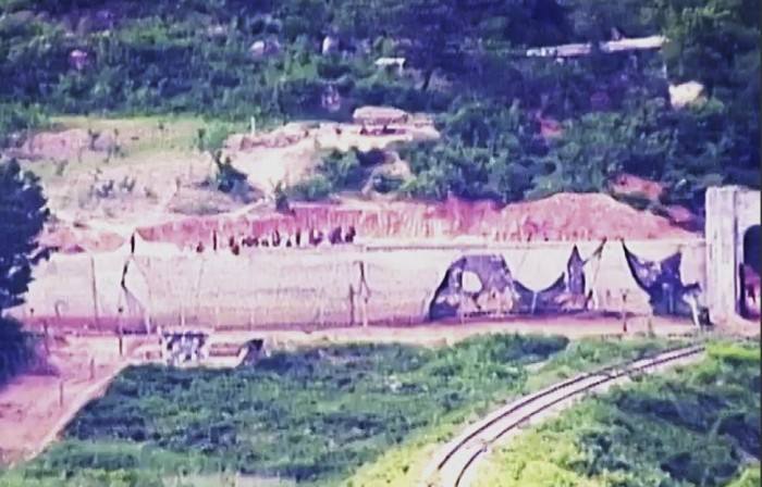 |
| North Korean soldiers installing structures presumed to be anti-tank barriers in the frontline area of the Demilitarized Zone (DMZ). Military authorities announced on June 18, 2024, that multiple North Korean soldiers working in the Demilitarized Zone (DMZ) were injured or killed in landmine explosions in June 2024. The Joint Chiefs of Staff stated, "North Korean troops appear to be pushing ahead with operations in the DMZ despite suffering numerous casualties from multiple mine blast incidents while conducting barren-land clearing and landmine operations across frontline areas." / Photo provided by the Joint Chiefs of Staff |
Alignment consultations limited to internal military and allies
In November of last year, the Ministry of National Defense proposed military talks to North Korea to discuss the MDL baseline issue, but received no response. With North Korea remaining unresponsive, the Joint Chiefs of Staff formed a task force early this year and has been consulting with the UN Command to reconcile the baseline.
The director general of the Defense Policy Bureau at the Ministry of National Defense stated during a briefing on the 6th that the MDL used by the UNC and the South Korean military must be aligned first before anything involving North Korea can proceed. He added that while applying the UNC standard shifts the line northward in some sections and southward in others, overall the two remain comparable.
In a Foreign Ministry statement issued the same day, North Korea stated that it would not discuss military sovereignty within its territory with an adversary. It signaled that it would defend its sovereign domain not through negotiations, but through the exercise of force. A defense ministry official reaffirmed the stance that military talks remain necessary to harmonize the MDL.
On the 5th, the South Korean military cleared a North Korean minefield south of the MDL for the first time, stating it would continue operations if North Korea did not remove the mines voluntarily. North Korea warned it would immediately respond if the South Korean military encroaches on its territory by even a single millimeter. Yet, there remains no agreement on where that territorial line actually lies.
If the MDL baseline diverges between the South Korean military and the UNC, determining incursions and establishing consistent levels of response will prove difficult.
With North Korea declaring "a single millimeter of territory" as its red line, whichever line is used as the standard becomes a volatile trigger for accidental clashes as clearing operations expand. Given that North Korea has rejected even discussing matters of military sovereignty, the government is left with two courses of action: first, the military and the UNC must definitively establish a single baseline; second, authorities must reach an agreement with the UNC on the scope and procedures of clearance operations—as well as measures to prevent friction with North Korea's perceived boundary line—and transparently communicate them to the public.
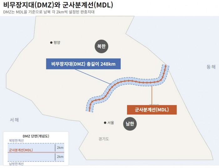 |
| An infographic explaining the geographic concepts of the Demilitarized Zone (DMZ) and the Military Demarcation Line (MDL). The DMZ is a 248-kilometer-long buffer zone spanning a total width of 4 kilometers, set 2 kilometers north and south from the Military Demarcation Line. A cross-sectional view of the DMZ at the bottom left illustrates the structure where the Military Demarcation Line sits between the Northern Limit Line and the Southern Limit Line, spaced 2 kilometers apart from each. / Gemini composite image, Source: Joint Chiefs of Staff |
Ku Pil-hyun
Most Read
-
1
Alteogen secures European patent for Keytruda SC,..

-
2
Trump shares map on social media labeling Strait o..

-
3
Celltrion seeks rheumatoid arthritis indication ex..

-
4
Kia Sportage outperforms Mazda CX-5 in German auto..

-
5
U.S. deploys carrier, 10,000 more troops to Middle..

-
6
Trump rejects Iran's offer to open Strait of Hormu..

-
7
N. Korea conducts first swarm attack drill with dr..

PEOPLE






HEADLINE NEWS
- Pyongyang calls DMZ explosion Seoul's fabrication and grave provocation
- U.S. Department of Defense completely halts use of blacklisted Anthropic AI
- 2026 Nobel Prize in Physics awarded to Francis Halzen for neutrino research
- French students take to streets, expressing frustration over economy, educa..

-
Address : In-Young Bldg., 34, Uisadang-daero 1-gil, Yeongdeungpo-gu, Seoul
Copyright by ASIATODAY CO., LTD. All rights resereved